More than 30 miles of the Emerald Network are currently in-progress; projects with funding for design, funding for construction or currently under construction. We continue to actively move projects forward by writing of comment letters, activating community support at public meetings, and providing technical assistance and resources. Seven of these projects are highlighted below- please check back as we continue to update their status!

In-Progress
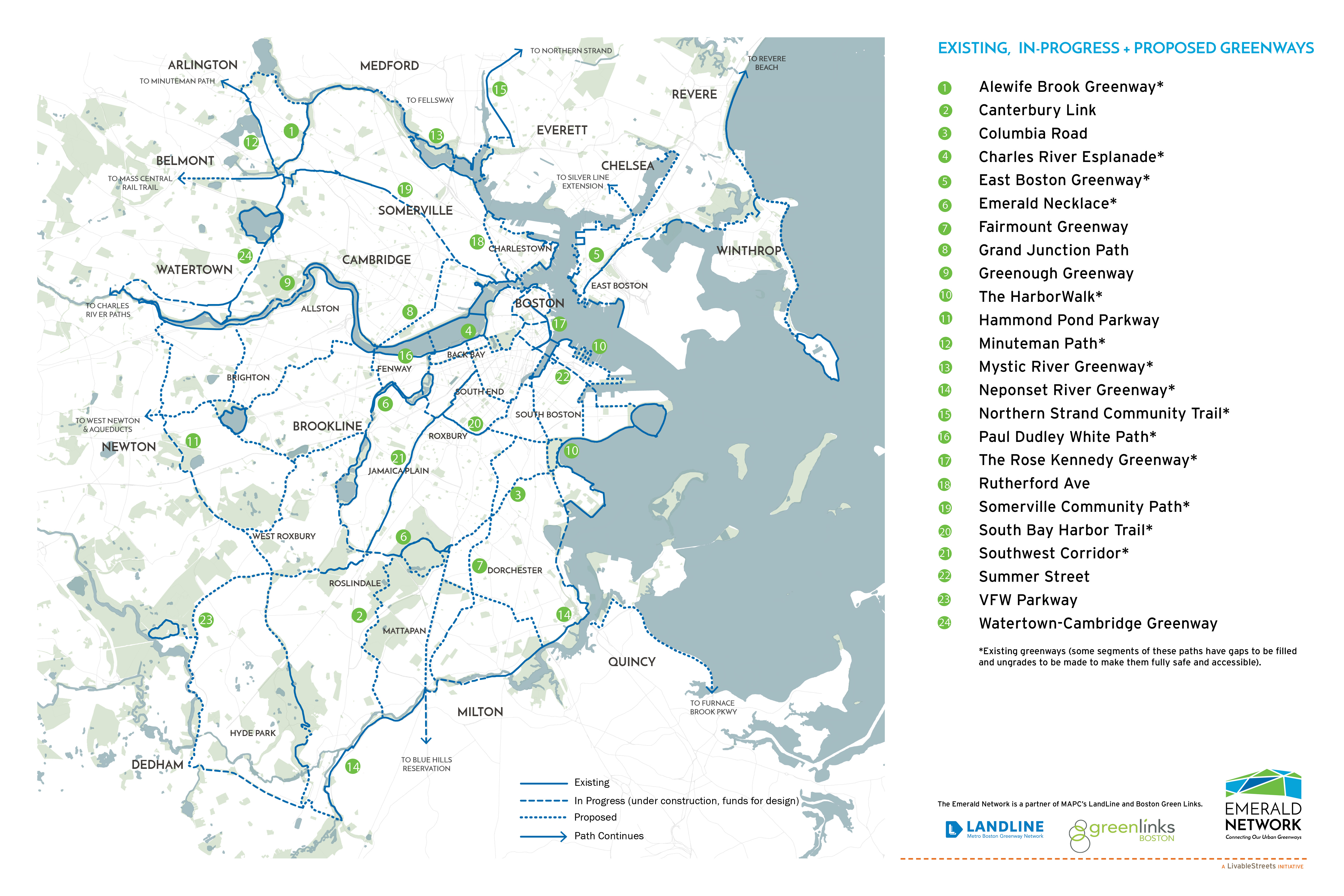
 Neponset River Greenway- DCR: A key section of the Neponset River Greenway - from Central Ave to Blue Hill Ave - is under construction and when complete, will provide the long-missing link to extend the off-road pedestrian and bike trail a continuous 10 miles through Dorchester, Mattapan, Hyde Park, and the Town of Milton. (photo credit: DCR)
 Greenough Greenway- DCR and The Solomon Foundation: This mile-long stretch along the Charles River between the Eliot Bridge and Arsenal Street Bridge is currently under construction and will feature a safe, shared-use path with enhanced parkland features when complete. (photo credit: The Solomon Foundation)
Proposed
 Columbia Road: Once envisioned as as a pleasant, green parkway along the Emerald Necklace, this traffic-filled corridor inhibits walking and biking between neighborhoods, stores, schools and open spaces. Along with LivableStreets, several neighborhood organizations are helping to reimagine this road as as a greenway connecting Franklin Park to Castle Island. (photo credit: NBBJ)
 Grand Junction Path: This proposed shared-use path will run alongside the existing tracks in the Grand Junction corridor from the Boston University Bridge to the planned extension of the Somerville Community Path (part of the Green line Extension). (photo credit: Friends of the Grand Junction Path)
 Roslindale Gateway Path: With grassroots support from WalkUP Roslindale, LivableStreets will be leading a Tufts Urban and Environmental Planning study to evaluate feasibility and build public support for a shared-use path to connect Forest Hills and Roslindale transit stations and serve as a new entrance to Arnold Arboretum. (photo credit: Halvorson Design)
 Roxbury to Fenway Connector: Boston Green Links is leading the design and community outreach process for a safe, green route to connect pedestrians and bicyclists using the Southwest Corridor to the Emerald Necklace and Fenway. (photo credit: Solomon Foundation and NBBJ)
 Sullivan Square Greenway Link: As part of a design charrette hosted by LivableStreets, Nelson/Nygaard identified several opportunities to improve non-motorized circulation in and around Sullivan Square. This concept envisions a shared-use path along an abandoned rail line to connect the Mystic River and Harborwalk paths in Somerville and Charlestown. (photo credit: Nelson/Nygaard, Alta Planning, The Cecil Group)
Get involved! Contact: [email protected]